...
- Press the "OK" button to start importing the shapefile into your database. When finished you should be able to see your new layer listed under the spatial schema.
Repeat the previous steps for the other zip file (CNTR_2014_20M_SH.zip) you have downloaded changing your configurarions according to the following:
Field name Value Input CNTR_RG_20M_2014 Schema spatial Table ctr_20m Primary key gid Geometry column geom Source SRID 4258 Target SRID 4326 Encoding UTF-8
2.4. Importing additional Countries metadata into the database
...
- You should now see a table listed in the left panel of QGIS.
- Click on the "DB manager" plugin button (
 ). On the left panel, expand the "PostGIS" node and should see the connection node you have created before (in this case called union-vms). Expand that node and you should see all the schemas that are used within the Union VMS application.
 - To start importing the DBF into the spatial database press the "Import layer/file" button (
 ). In the new window, do the following configurations
Field name Value Input CNTR_AT_2014 Schema spatial Table ctr_metadata - Press the "OK" button to start importing the shapefile into your database. When finished you should be able to see your new layer listed under the spatial schema.
...
- Open QGIS
- Click on the "DB manager" plugin button (). On the left panel, expand the "PostGIS" node and should see the connection node you have created before (in this case called union-vms). Expand that node and you should see all the schemas that are used within the Union VMS application.
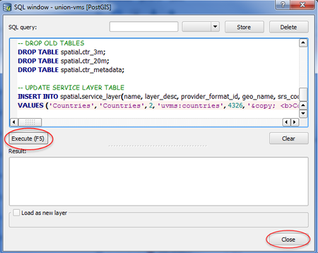
To prepare the data you will need to run some SQL scripts. To do that, press the "SQL window" button (
 ). In the new window paste the following SQL script:
Code Block language sql -- CREATE COUNTRIES TABLE CREATE TABLE spatial.countries AS (SELECT a.gid, a.geom AS geom, b.geom AS geom_20, a.cntr_id, c.iso3_code AS code, c.name_engl AS name FROM spatial.ctr_3m AS a, spatial.ctr_20m AS b, spatial.ctr_metadata AS c WHERE a.cntr_id = b.cntr_id AND a.cntr_id = c.cntr_id); ALTER TABLE spatial.countries OWNER TO spatial; -- ADD NECESSARY COLUMNS FOR UNIONVMS ALTER TABLE spatial.countries ADD COLUMN enabled character varying(1) NOT NULL default 'Y'; ALTER TABLE spatial.countries ADD COLUMN enabled_on timestamp without time zone; -- ADD PRIMARY KEY ALTER TABLE spatial.countries ADD PRIMARY KEY (gid); -- ADD SEQUENCE CREATE SEQUENCE spatial.countries_seq INCREMENT 1 MINVALUE 1 MAXVALUE 9223372036854775807 START 256 CACHE 1; ALTER TABLE spatial.countries_seq OWNER TO spatial; -- ADD SPATIAL INDEXES CREATE INDEX spatial_countries_geom_index ON spatial.countries USING gist (geom); CREATE INDEX spatial_countries_geom_20_index ON spatial.countries USING gist (geom_20); -- DROP OLD TABLES DROP TABLE spatial.ctr_3m; DROP TABLE spatial.ctr_20m; DROP TABLE spatial.ctr_metadata; -- UPDATE SERVICE LAYER TABLE INSERT INTO spatial.service_layer(name, layer_desc, provider_format_id, geo_name, srs_code, short_copyright, long_copyright, is_internal, style_geom, style_label, style_label_geom, subtype) VALUES ('Countries', 'Countries', 2, 'uvms:countries', 4326, '© <b>Countries</b>: EuroGeographics for the administrative boundaries.', '© <b>Countries</b>: EuroGeographics for the administrative boundaries.', 'Y', 'countries', 'countries_label', 'countries_label_geom', 'others');- Press the "Execute (F5)" button and when finished press the "Close" button.
- On the main window of the "DB manager" plugin, refresh the spatial schema and select the table named "service_layer" on the left panel. Select the "Table" tab on the right panel and check the id value of the recently created row (row where name is Countries).
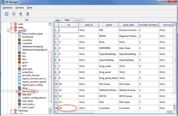
If this value is different tham 14, please update the following script by replacing 14 with your value. Run the script like you just did before this step.
Code Block language sql -- UPDATE AREA LOCATION TYPES TABLE INSERT INTO spatial.area_location_types(service_layer_id, type_name, area_type_desc, area_db_table, is_system_wide, is_location) VALUES (14, 'COUNTRY', 'Country', 'countries', 'N', 'N');
You have now finished all necessary steps to setup the Countries spatial dataset in the Union VMS application.